






For years, location-based open-source intelligence (OSINT) has relied heavily on a steady stream of user-generated geographic data. Geotagged social media posts with embedded latitude and longitude coordinates have long been a goldmine for tracking regional trends, monitoring real-time events, and understanding on-the-ground public sentiment. Intelligence professionals and data scientists have historically used this passively-generated location-based data to aggregate real-time insights for everything from tracking public sentiment to monitoring natural disasters.
However, the era of effortless geographic tracking is coming to an end. Geotagged social media data is becoming increasingly scarce, making it significantly harder for security teams to gather a complete picture of location-based intelligence.
The primary driver behind the diminishing use of geotags is a massive shift in digital privacy standards. For instance, major platform-level policy interventions, such as Apple’s November 2021 iOS privacy update, changed the default consent model for device tracking. Instead of requiring users to actively opt out of location tracking, iPhone users must now explicitly opt in.
As a result of these strengthened privacy controls, a massive behavioral shift occurred: within a year of the iOS update, 62% of affected users chose to opt out of location tracking entirely. This platform-mediated behavioral barrier has drastically reduced the availability and visibility of granular location traces, creating complex new blind spots for researchers and intelligence analysts.
With precise coordinates disappearing from social feeds, security practitioners and OSINT investigators are left facing a major data void. Relying purely on traditional keyword or hashtag searches to find location-specific events is highly inefficient. In fact, as little as 7% of social media posts actually contain hashtags. If an analyst is scanning 10,000 posts a day looking for a specific hashtag, they could be missing up to 9,300 posts that hold critical intelligence.
To compensate for missing geotags, security practitioners have traditionally had to spend valuable time performing manual, tedious searches for specific local details like street names, landmarks, and local businesses to figure out where an event is taking place.
To overcome the increasing scarcity of explicit location data, the intelligence industry is leveraging artificial intelligence and spatial technologies.
AI-powered keyword optimization tools like Echosec’s new AI-powered “Optimize” feature are designed specifically to bridge this data gap. Instead of relying on users to share their precise coordinates, AI automatically generates hyper-relevant, location-based keywords for an investigator’s search. If an analyst is looking into a specific neighborhood, the AI will suggest relevant landmarks, tourist attractions, schools, government buildings, and businesses to monitor. This instantly converts manual, time-consuming research into an automated process, significantly increasing the volume and relevance of the data collected.
Geo-based search combined with AI keyword generation is taking OSINT to the next level. Geofencing allows teams to draw virtual perimeters around physical sites, such as corporate offices, foreign meeting sites, or public gatherings, to monitor digital activity strictly within those areas. This means you don’t need to know what keywords or hashtags you are looking for; you only need to know where to look. This is incredibly valuable for real-time executive protection and monitoring civil unrest, as it surfaces visual intelligence and early warnings directly from the scene, cutting out irrelevant noise.
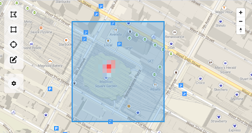
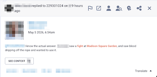
The decline of the geotag is a victory for consumer privacy, but it isn’t the end of location-based intelligence. By leveraging AI-driven keywords and hyper-local geofencing, security teams can move beyond broad geographic searches. These smart tools alleviate research bottlenecks, allowing analysts to redirect their expertise away from exhaustive data hunting and toward the critical analysis needed to respond to threats before they escalate. The geotag may be fading, but our situational awareness remains sharper than ever.
Don’t let the intelligence gap compromise your situational awareness. Ready to move from tedious manual searches to immediate, actionable insights? Book your Echosec demo today and empower your team with the next generation of location-based insight.
此内容由惯性聚合(RSS阅读器)自动聚合整理,仅供阅读参考。 原文来自 — 版权归原作者所有。