





The map service cache directory must reside in a server cache directory. A server cache directory is a parent directory that has been
registered with ArcGIS Server as a directory in which to store map cache directories.
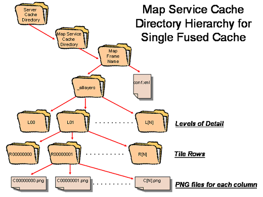
A single-fused cache is organized into a 3-dimensional grid corresponding to a directory hierarchy that has upper level directories (labeled as
levels of detail) that contain directories (labeled with row numbers) containing all the image tiles (labeled with column numbers) for a given row.
Multi-layer caches have an additional level of hierarchy at the top consisting of directories (labeled with layer names) that contain the level-of-
detail directories. The tiles are all the same size and have pixel dimensions that are a user-selectable 128, 512, or 1024 pixels in size. Tiles are 3
band (8 bit each) PNG-24 images with the background color set to transparent by default. If no background color is set in the map document
the background color will default to 253,253,253. This behavior can be changed in ArcMap.
此内容由惯性聚合(RSS阅读器)自动聚合整理,仅供阅读参考。 原文来自 — 版权归原作者所有。