










Latest assessments indicate that beneath the surface of the equatorial eastern Pacific, cradle of El Niño, a powerful event may be taking shape, one that could surpass the intensity of the 2023 event and rival the formidable episode of 2015.
In 2023, India had recorded a below-normal monsoon (6 per cent below normal) while 2015 turned out to be the 10th driest year in a century with a rainfall deficit of 14 per cent. But all El Nino events have not led to a drought as evidenced in 1997, when the country witnessed a normal monsoon despite a strong El Nino.
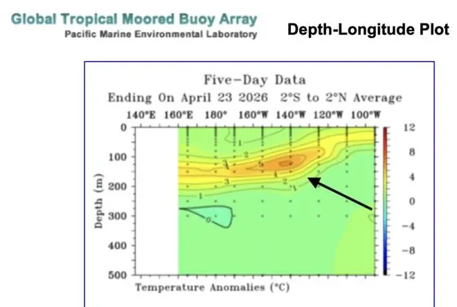
Below the surface of the ocean, conditions indicate a significant accumulation of heat (in orange), aiding El Nino development.
“Evolving conditions have led sections of the media to invoke the spectre of a so-called ‘Godzilla El Niño,’ says Swadhin Behera, Director of the Application Research Laboratory at the Japan Agency for Marine-Earth Science and Technology, visiting professor at the University of Tokyo, and noted tracker of the El Nino phenomenon.
Sub-surface warmth
El Niño is initiated with accumulation of warmer water below surface, a reservoir of heat content, along the equatorial Pacific, often weeks or even months before any rise in sea-surface temperatures. Simultaneously, upwelling of cold, nutrient-rich waters off the South American coast weakens. This allows the sub-surface warmth to intensify, deepen and gradually shift eastward, laying the groundwork for a full-fledged event.
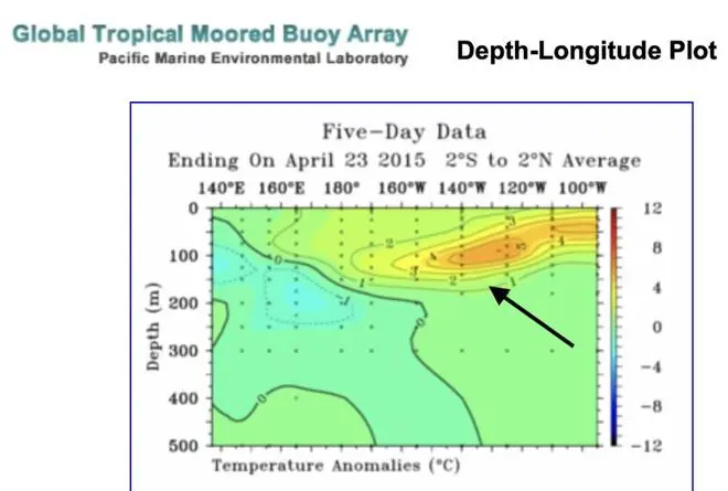
Evolving sub-surface heat in the tropical Pacific is comparable with what was observed during the development of the very strong 2015 El Nino (ocean heat shown in and orange yellow) at this time of the year.
Further aiding the process are westerly wind bursts (WWBs), or episodic reversal of the tropical Pacific trade winds, and eastward-propagating pulses of warm water known as Kelvin waves from Asia-Australia to South America. Travelling at depths of roughly 100–200 metres, these waves traverse the Pacific in two to three months, ferrying heat toward the South American coast and acting as a crucial precursor to El Niño.
Westerly wind bursts
WWBs are intense, short-lived disruptions of the prevailing easterlies that can trigger and amplify El Niño events. By generating these eastward-moving warm-water pulses, they accelerate sub-surface ocean warming and help determine both the timing and eventual strength of an event. Emergence of El Niño conditions is typically underpinned by a substantial build-up of such warm sub-surface waters across the equatorial Pacific.
WWBs deepen the boundary between warm surface water and cold deep water (thermocline), raising sea levels, and initiating the warming as seen in El Niño events. Behera explained to businessline the link between the initial WWB earlier this month, and corresponding eastward propagation of warm Kelvin waves.
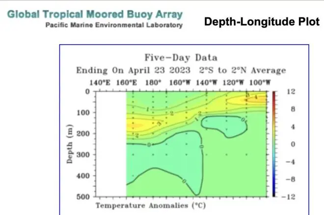
The sub-surface heat was notably lower ahead of the 2023 El Nino event (mostly yellow, and no orange in graphic).
“In the first attached plot, one can see the initial WWB, along with corresponding propagation of Kelvin waves helping to initiate El Niño conditions. At this stage, it remains uncertain how many additional WWBs will occur later in the season. ”However, sub-surface conditions (second plot) indicate a significant accumulation of sub-surface heat, comparable to what was observed during the development of the 2015 El Niño (third plot) at this time of the year. In contrast, the sub-surface heat content was notably lower in 2023 (fourth plot).
Stronger westerly wind bursts facilitate generation of eastward-propagating Kelvin waves, which push warm water from the west to the east Pacific. Accumulation of warm water in the eastern Pacific below surface usually precedes surface-level warming, acting as a crucial indicator of a developing El Niño.
Published on April 26, 2026