
惯性聚合 高效追踪和阅读你感兴趣的博客、新闻、科技资讯
阅读原文 在惯性聚合中打开

推荐订阅源

钛媒体:引领未来商业与生活新知
钛媒体:引领未来商业与生活新知
MongoDB | Blog
MongoDB | Blog
博客园_首页
博客园 - 三生石上(FineUI控件)
博客园 - 聂微东
B
Blog RSS Feed
D
Docker
IT之家
IT之家
大猫的无限游戏
大猫的无限游戏
OSCHINA 社区最新新闻
OSCHINA 社区最新新闻
阮一峰的网络日志
阮一峰的网络日志
罗磊的独立博客
Recent Announcements
freeCodeCamp Programming Tutorials: Python, JavaScript, Git & More
A
About on SuperTechFans
The GitHub Blog
The GitHub Blog
G
Google Developers Blog
V
V2EX
量子位
雷峰网
雷峰网
月光博客
月光博客
云风的 BLOG
云风的 BLOG
奇客Solidot–传递最新科技情报
奇客Solidot–传递最新科技情报
T
Tailwind CSS Blog

Business News Today: Latest Business News, Finance News

Markets’ dilemma: Trust the bark or wag of oil prices The sector call illusion Bandu’s Blockbusters For April 12, 2026 Mastering Derivatives: Does Lag Impact Effectiveness Of OI? Who Am I? April 12, 2026 Index Outlook: Rising From Dire Straits US Market Outlook: Gaining Strength Bullion Cues: Gold And Silver Futures Face Barrier F&O Tracker: Tentative Shift In Trend F&O Strategy: Buy L&T Put Maruti Suzuki to launch 4 EVs by 2031 India Inc flags surge in cost of packaging raw material, seeks relief measures India-flagged LPG tanker Jag Vikram crosses Strait of Hormuz after US-Iran ceasefire Muted pricing power, rising costs to curb benefits of demand in cement sector: HDFC Securities Iran's new supreme leader Mojtaba Khamenei has severe and disfiguring wounds, sources say No road tax, registration fees for electric vehicles priced up to ₹30 lakh till March 2030: Delhi’s draft EV policy Central Railway to run four special local trains for Ambedkar Jayanti West Asia tensions push up costs for India; further impact hinges on stability: Report ED initiates fresh raids against former Bengal minister Chatterjee in teacher recruitment scam Election Commission reverses Mittal’s DVAC posting, appoints him DGP, TN Armed Police Israel and Lebanon are expected to hold talks. Here’s what to know US, Iran set for peace talks but doubts emerge over Lebanon, sanctions Cotton Association revises output estimates for 2025-26 up at 324 lakh bales of 170 kg each Orbicular gets USFDA’s tentative nod for generic Semaglutide Injection in partnership with Apotex Malls, high-streets in NCR clock 45% rise in leasing of retail spaces in Jan-Mar: C&W FIIs pull ₹28,375 crore in five sessions; domestic buyers cushion fall as indices post best week in months Nifty and Bank Nifty Prediction for the week 13 Apr’26 to 17 Apr’26 by BL GURU Proposed Trump arch in Washington DC includes winged figure, eagles, lions and gold inscriptions 'Ladakh' replaces 'Jammu and Kashmir' in Aadhaar records for UT residents Misri ends US trip with focus on civil nuclear cooperation and LPG exports
Rain, thunderstorms, lightning likely as western disturba...
2026-04-30 · via Business News Today: Latest Business News, Finance News
Showers and cooler weather (light green. while and blue) in East and North-East India pushes back high temperature (in golden yellow) to Central India as per satellite pictures on Thursday morning.

Showers and cooler weather (light green. while and blue) in East and North-East India pushes back high temperature (in golden yellow) to Central India as per satellite pictures on Thursday morning. | Photo Credit: www.meteologix.com

Leading edge of an cooler western disturbance has crossed into India, manifesting as a cyclonic circulation over north Pakistan and adjoining parts of Kashmir on Thursday morning. A successor disturbance is likely to affect the hills of North-West India from Saturday, India Meteorological Department (IMD) said.

A parent upper-air trough passed this (Thursday) morning through Amritsar; Mudki; and Bathinda in Punjab. The disturbance has triggered a cyclonic circulation over Punjab, from which a trough extended southward into south-west Rajasthan. An additional upper-air cyclonic circulation is active over north-east Rajasthan.

Lid on mercury

The constellation of weather systems is likely continue to put a lid on mercury and usher in a spell of pre-monsoon weather marked by rain; thunderstorms; occasional lightning; and possibility of hail in isolated areas. Meanwhile, the robust anti-cyclonic circulation responsible for the scorching summer conditions continued to dominate interior Maharashtra and neighbouring Telangana. 

A couple of helpful troughs of low-pressure lying elsewhere will help transmit the tolerable weather to other parts of the country. A trough ran across from north-east Madhya Pradesh to a cyclonic circulation over north-east Bangladesh caressing Jharkhand and plains of West Bengal. A trough/wind discontinuity extended North Interior Karnataka to Gulf of Mannar cutting across South Interior Karnataka and Tamil Nadu. 

Rain, thundershowers
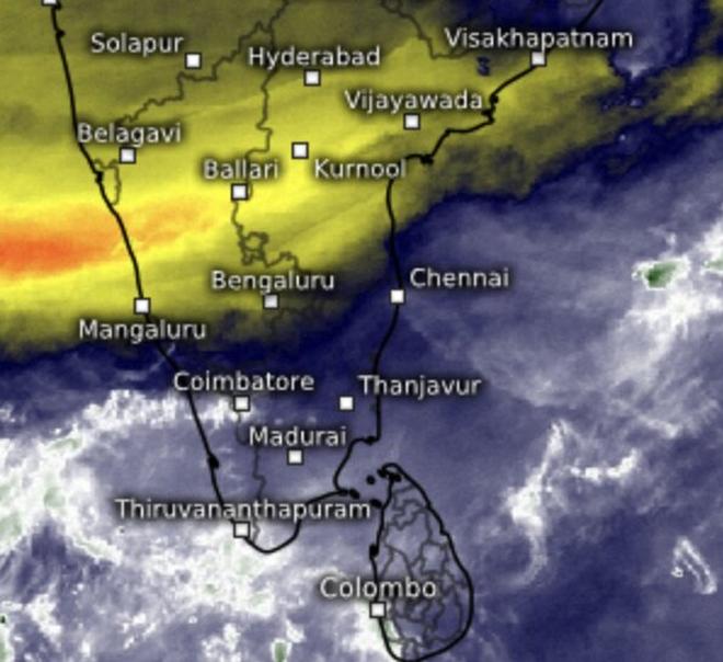
Wet weather and clouds holds over South Peninsula back hot and dry air (golden yellow) to Central India on Thursday morning.

Wet weather and clouds holds over South Peninsula back hot and dry air (golden yellow) to Central India on Thursday morning. | Photo Credit: www.meteologix.com/in

Rain or thundershowers occurred at most places over Himachal Pradesh; West Uttar Pradesh; Jharkhand; hills and plains of West Bengal and Sikkim; Jammu and Kashmir and Ladakh; East Uttar Pradesh; and at many places over West Rajasthan; West Madhya Pradesh; East Madhya Pradesh; East Rajasthan; Odisha; Chhattisgarh; Coastal Andhra Pradesh and Yanam until 5.30 am this morning.

Bengaluru bore the brunt as it lay directly in the path of a trough/wind discontinuity, recording heavy rainfall accompanied by hail, with 11 cm falling in a short span. Rain or thundershowers also occurred at many places across South Interior Karnataka; Bihar; Assam; Meghalaya; and the north-eastern states of Nagaland, Manipur, Mizoram, and Tripura; as well as in Kerala and Mahe; Tamil Nadu, Puducherry and Karaikal; and Lakshadweep.

Australia season ends 

Meanwhile, the wet season across northern Australia is likely drawing to to a close around its usual time, removing a potential obstacle to the timely onset and progression of the south-west monsoon over the Maldives, Sri Lanka, and India.

The Australian monsoon, which typically runs from October 1 to April 30, this year delivered approximately 680 mm of rainfall in northern Australia between October 1 and April 20, about 42 per cent above the long-term 1961–1990 average. With transition to dry season now underway, the Australian Bureau of Meteorology has forecast relatively little rainfall across most of northern Australia during the fortnight from May 2 to 15. 

Published on April 30, 2026