








Researchers at Utrecht University in the Netherlands have launched Paleolatitude.org, an online tool that allows users to track the geographical journey of any location on Earth over the last 320 million years.
This tool pinpoints the ancient latitude of any modern location, tracing its journey back to the peak of the supercontinent Pangaea.
It is like a time machine. Depending on the era, the ground beneath your feet could be a tropical seabed, a toxic volcanic wasteland, or a glacial shelf.
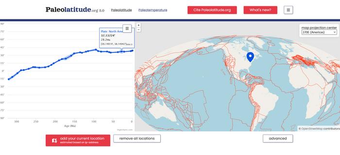
The project was born from a geographical puzzle. Geoscientists studying fossils in Winterswijk, Netherlands, found remains of flora and fauna that looked suspiciously like they belonged in the modern-day Persian Gulf.
Was the entire world a sweltering sauna back then? Not necessarily.
“Latitude determines the angle of the sun’s rays and thus also the local climate,” the researchers noted.
The tool helps distinguish whether ancient environmental changes were caused by global climate shifts or simple tectonic movement. For example, it confirmed that 245 million years ago, the Netherlands had a desert climate not just because the world was warmer, but because the landmass was physically located at the same tropical latitude as the modern-day Persian Gulf.
“This means that, for the first time, a truly global model is now available that allows you to link those rocks to their original plates, which have since disappeared into the Earth’s mantle. The global journey of those rocks can now also be traced,” Professor Douwe van Hinsbergen noted.
The reconstruction process follows a two-step method: first, scientists “unfold” mountain ranges to see how tectonic plates moved relative to one another.
It helped identify traces of lost continents, such as Greater Adria, Argoland, and the Tethys Himalayas. These landmasses have long since been swallowed by the Earth’s mantle, but left their fingerprints in the folded rocks of the Mediterranean and Indonesia.
Second, the exact latitude of these plates was determined by analyzing magnetic minerals trapped within ancient rocks.
Because the angle of Earth‘s magnetic field varies from the poles to the equator, these minerals act as a prehistoric GPS, allowing geoscientists to pinpoint a rock’s original location on the globe and chart its journey over millions of years.
Beyond mapping landmasses, the Paleolatitude.org tool serves as a powerful resource for paleontologists to track how biodiversity shifted across different climates over millions of years.
Pinpointing the exact historical locations of fossil-rich rocks, researchers can now analyze how species responded to ancient mass extinctions and rapid temperature changes.
Interestingly, this “three-dimensional” approach reveals which latitudes served as refuges and which became uninhabitable. It could provide insights into the resilience of life and migration patterns, helping us understand modern biodiversity challenges.
While it currently spans 320 million years back to the era of Pangaea, future updates will extend back to the Cambrian explosion 550 million years ago.
Ultimately, the model would allow mapping climate evolution and the resilience of biodiversity, and would invite the public to explore the deep-time travels of any modern destination via Paleolatitude.org.

Get the latest in engineering, tech, space & science - delivered daily to your inbox.
Mrigakshi is a science journalist who enjoys writing about space exploration, biology, and technological innovations. Her work has been featured in well-known publications including Nature India, Supercluster, The Weather Channel and Astronomy magazine. If you have pitches in mind, please do not hesitate to email her.
此内容由惯性聚合(RSS阅读器)自动聚合整理,仅供阅读参考。 原文来自 — 版权归原作者所有。