


Scientists and officials are keeping a close eye on conditions brewing in the Pacific Ocean that could spike temperatures and smash global heat records in the year ahead.
It’s still too early to get a definitive picture, but there are signs that a so-called super El Niño could develop this year, supercharging extreme weather events around the world. Some forecasts are suggesting it could become one of the strongest ever recorded.
Alongside heating from the human-caused climate crisis, this could put the world on track to once again temporarily breach the 1.5C average temperature rise over preindustrial levels – the critical climate threshold that experts have warned comes with a host of catastrophic consequences. Some models show that temperature anomalies could even push past that point next year and go beyond a 2C increase for the first time in recorded history.
What would a super El Niño look like and what would it mean for the global climate? I’ll explain, after this week’s most important reads.
Essential reads
-
Stern warning: one man’s mission to clear the rotting boats poisoning Cornwall’s creeks
-
On the trail with the hunters who believe shooting big game can save Africa’s wildlife
In focus
Temporary breaches of that 1.5C mark aren’t on the same level of concern as longer-term temperature increases, but they are stepping stones on a perilous path.
Marc Alessi, a fellow at the Union of Concerned Scientists said this week in an analysis: “While the majority of models predict global monthly temperature anomalies will remain below 2C, the fact that there’s a nonzero chance of +2C happening is shocking,” adding that such an increase would push the world closer to dangerous tipping points.
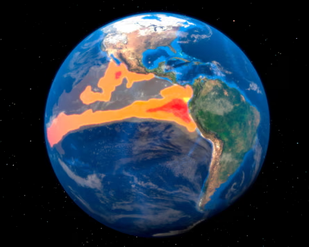
Before we go deeper into what the models are showing, a quick refresher: El Niño is a natural climate phenomenon characterised by the warming of the ocean surface in the central and eastern tropical Pacific Ocean, that typically occurs every two to seven years and tends to last between nine and 12 months. During El Niño years, the winds that would push warm waters to the west soften or shift direction, enabling the surface waters in that part of the Pacific to warm.
El Niño is one of three states scientists observe, and each helps shape important weather predictions for the year that follows. La Niña, conversely, happens when sea surface temperatures are below average, and neutral conditions are defined when neither El Niño nor La Niña are present and surface temperatures are about average. These events generally develop between April and June but don’t reach full strength until later in the year, between October and the following February.
Warming and cooling at sea surface during El Niño and La Niña can range from 1C to 3C, and have enormous effects on precipitation, drought, heat and climate disasters in different regions, depending on which direction they go.
Right now, conditions are shifting out of La Niña and into a neutral pattern, according to the latest outlook from the US Climate Prediction Center. But models are showing a rapid transition toward El Niño. A forecast from the International Research Institute for Climate and Society at Columbia University, published on Monday, gave a 70% chance of El Niño developing by June and up to 94% probability that it would persist through the end of the year.
While the models suggest there is a good chance of something big developing, experts have also pointed out these readings tend to skew higher because of overall warming trends that affect baselines. Spring also tends to provide a slightly muddied picture, due to natural transitions that happen during this time of year. But the early forecasts suggests that there’s a strong chance of El Niño developing.
The UK Met Office said in a statement released with its 15 April forecast: “There is growing confidence that this event could sit at the upper end of the historical range. Scientists are telling us that this could be the strongest El Niño event so far this century.”
A “super” El Niño isn’t a term used by the Met Office or by many other scientific organisations, but it is used to denote a very strong El Niño, where the warming of sea surface temperatures is higher than 2C above normal. This has only occurred a few times since 1950 and only once have temperatures surged past 2.5C. The US Climate Prediction Center gave a 50% chance that a strong or very strong El Niño would develop between November and January.
Each El Niño event is unique, with impacts that are highly variable and change considerably depending on region and season. But the cycle tends to create drought and heat across Australia, around southern and central Africa, in India and in parts of South America, including in the Amazon rainforest. Heavy precipitation, meanwhile, could hit the southern tier of the US, parts of the Middle East, and south-central Asia. It also flips hurricane activity, suppressing development in the Atlantic Ocean while increasing the likelihood that powerful tropical storms will churn out of the Pacific.
The stronger it is, the more likely it will supercharge weather events around the world. A super El Niño in 2015 brought severe drought in Ethiopia, water supply shortages in Puerto Rico, and smashed records after unleashing a vicious hurricane season in the central-north Pacific, according to an analysis by US federal scientists.
There’s still some uncertainty about whether conditions will coalesce to create severe shifts this year. Climate scientists are also quick to point out that each event is unique and there’s considerable variability in intensity and outcomes. But experts said the forecasts can help communities around the world to prepare for extreme weather in the months ahead – an essential tool in a warming world.
Predictions in spring can’t account for unexpected changes that can happen over the summer and the models don’t show a “slam dunk”, according to climate scientist Tom Di Liberto. But, he said, “the risk is high enough to be worried”.
Read more: