



- DESCRIPTION
- TABLE OF CONTENTS
- METHODOLOGY
- DOWNLOAD PDF
Inertial Navigation Systems Market by Application (Munition, Airborne, Marine, Land, Unmanned), Grade (>10,1-10, 0.1-1,0.01-0.1/hr), Technology (Integrated GNSS/INS, Hybrid), Solution (Ring Laser, Fiber-Optic, MEMS), Region - Global Forecast To 2030

USD 11.92 BN
MARKET SIZE, 2030

CAGR 6.1%
(2026-2030)

300
REPORT PAGES

120
MARKET TABLES
Source: Secondary Research, Interviews with Experts, MarketsandMarkets Analysis
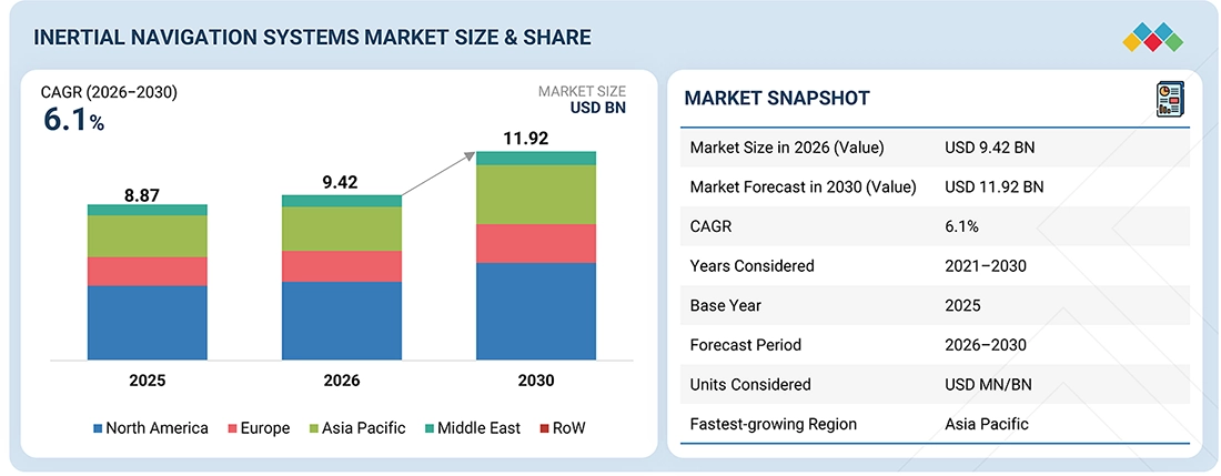
The Inertial Navigation Systems Market is estimated to be USD 9.42 billion in 2026 and projected to reach USD 11.92 billion by 2030, growing at a CAGR of 6.1% from 2026 to 2030. Market growth is driven by rising demand for accurate navigation across defense and commercial platforms, as well as the increasing need for reliable systems in GPS-denied environments.
INERTIAL NAVIGATION SYSTEMS MARKET Size & Forecast
• 2026 Market Size (Value): USD 9.42 BN
• 2030 Market Forecast (Value): USD 11.92 BN
• CAGR: 6.1% from 2025 to 2030
• North America: Accounted for a 45.5% Revenue Share
• Missile & Munition Segment: Held the Largest Share
KEY TAKEAWAYS
-
Paragraph Content
The inertial navigation systems market is supported by rising defense spending and ongoing modernization programs across major economies. Increasing geopolitical tensions are driving the need for reliable navigation systems in advanced platforms and mission-critical operations. Governments are also focusing on strengthening domestic capabilities to ensure supply stability. The market is expected to grow steadily as countries continue to invest in long-term defense and technology development.
-
By Region
The North America inertial navigation systems market accounted for a 45.5% revenue share in 2025.
-
By Application
The missile & munition segment is expected to have the largest market share during the forecast period.
-
By Grade
The navigation segment is projected to be fastest growing during the forecast period.
-
By Technology
The integrated GNSS/INS segment is projected to be the most dominant during the forecast period.
-
By Solution
The algorithm & processor segment is projected to be the most dominant during the forecast period.
-
Competitive Landscape- Key Players
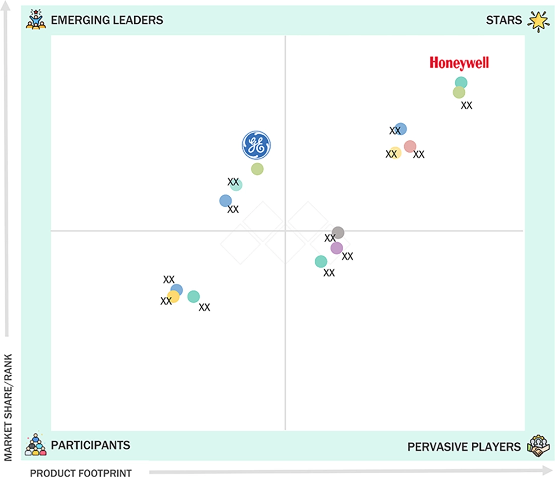
Honeywell International Inc, Northrop Grumman Corporation, and Hexagon AB, among others, were identified as some of the star players in the inertial navigation systems market, given their strong market share and product footprint.
-
Competitive Landscape- Other Players
VectorNav Technologies, SBG Systems, and Inertial Labs Inc, among others, have distinguished themselves among startups and SMEs by securing strong footholds in specialized niche areas, underscoring their potential as emerging market leaders
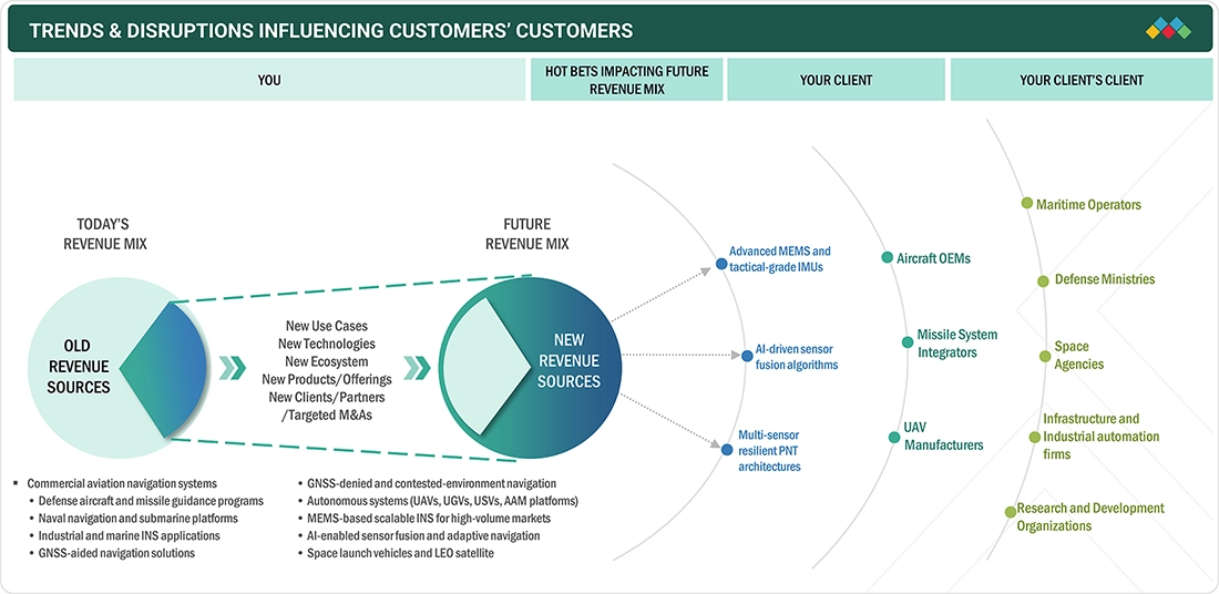
TRENDS & DISRUPTIONS IMPACTING CUSTOMERS' CUSTOMERS
The Inertial Navigation Systems Industry is changing as the needs of defense and commercial users keep evolving. Currently, there is a strong demand for dependable navigation in platforms like aircraft, missiles, and autonomous systems, especially in situations where GPS is not available. Going forward, the focus is likely to move toward more advanced and integrated systems that can deliver better accuracy and overall performance. There is also growing attention on sensor fusion, processing, and system integration to ensure everything works smoothly across different platforms.
Source: Secondary Research, Interviews with Experts, MarketsandMarkets Analysis
INERTIAL NAVIGATION SYSTEMS MARKET DYNAMICS

Drivers
Impact
Level
-
Rising emphasis on assured and resilient navigation architectures

-
Expansion of autonomous and unmanned platform deployments


RESTRAINTS
Impact
Level
-
High cost of navigation-grade inertial systems

-
Cumulative drift and dependence on external aiding for long-duration missions


OPPORTUNITIES
Impact
Level
-
Integration with Low Earth Orbit satellite constellations and hybrid navigation architectures

-
Growth of urban air mobility and advanced air mobility platforms


CHALLENGES
Impact
Level
-
Maintaining long-term accuracy under extended mission durations

-
Environmental sensitivity and performance stability

Source: Secondary Research, Interviews with Experts, MarketsandMarkets Analysis
Military and commercial platforms are increasingly operating in environments where GPS signals can be weak, jammed, or unavailable. This is creating a strong need for navigation systems that can work independently and still provide accurate positioning. Inertial navigation systems are being widely adopted across aircraft, missiles, naval vessels, and autonomous systems to ensure continuous navigation. As modern operations become more complex, the focus on reliable and resilient navigation solutions continues to grow.
High-performance inertial navigation systems, especially navigation-grade solutions, involve advanced sensors and complex technologies, which make them expensive. Many platforms, particularly smaller or cost-sensitive ones, face challenges in adopting these systems due to budget constraints. In addition, integration and maintenance can increase overall costs, making widespread adoption across all applications difficult.
There is increasing interest in combining inertial navigation systems with other technologies such as GNSS and Low Earth Orbit satellite constellations. These hybrid systems help improve accuracy and reliability by compensating for the limitations of standalone systems. As new satellite networks continue to expand, they are creating opportunities for more advanced and robust navigation solutions that can perform well even in challenging conditions.
Inertial navigation systems tend to accumulate small errors over time, which can affect accuracy during long missions. This becomes a challenge for applications that require continuous operation without external correction. While integration with other systems can help reduce these errors, ensuring consistent accuracy over extended durations remains a key challenge for system developers.
INERTIAL NAVIGATION SYSTEMS MARKET SIZE, SHARE & ANALYSIS: COMMERCIAL USE CASES ACROSS INDUSTRIES
| COMPANY | USE CASE DESCRIPTION | BENEFITS |
|---|---|---|
|
|
Supply of inertial navigation systems for commercial and military aircraft platforms, including flight control, navigation, and attitude reference systems used across Boeing and Airbus aircraft as well as US military aviation programs | High reliability for aviation navigation | Proven performance across commercial and defense platforms | Continuous positioning in GPS-degraded environments | Integration with avionics and flight management systems |
|
|
Development and supply of advanced inertial navigation systems such as LN-100G for military aircraft, missiles, and precision guided munitions used by the US Department of Defense | High-precision navigation for mission-critical applications | Support for GPS-denied operations | Widely deployed across airborne and weapon systems | Strong integration with defense platforms |
|
|
Development of Sigma family inertial navigation systems used in naval vessels, submarines, and military aircraft for navigation, pointing, and stabilization applications | Very high accuracy and low drift performance | Suitable for long-duration missions | Strong adoption in naval and defense platforms | Proven performance in harsh environments |



Logos and trademarks shown above are the property of their respective owners. Their use here is for informational and illustrative purposes only.
INERTIAL NAVIGATION SYSTEMS MARKET ECOSYSTEM
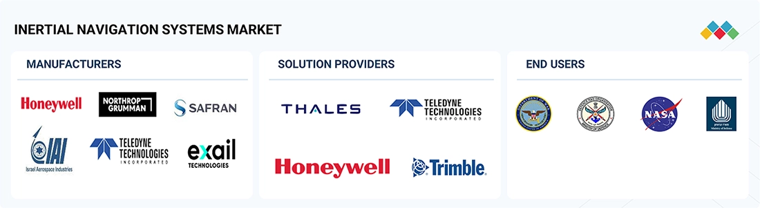
The inertial navigation systems market ecosystem includes manufacturers, solution providers, and end users working across defense, aerospace, and industrial applications. Companies such as Honeywell International Inc., Northrop Grumman Corporation, Safran Electronics & Defense, Israel Aerospace Industries Ltd., Teledyne Technologies Incorporated, and Exail SAS develop and supply core systems, while players like Thales Group, Honeywell International Inc., Teledyne Technologies Incorporated, and Trimble Inc. focus on integration and positioning solutions. Key end users include the United States Department of Defense, Defence Research and Development Organisation (India), NASA, and Israel Ministry of Defense, with the market largely driven by government programs, contracts, and advanced platform deployments.
Logos and trademarks shown above are the property of their respective owners. Their use here is for informational and illustrative purposes only.
INERTIAL NAVIGATION SYSTEMS MARKET SEGMENTS
Source: Secondary Research, Interviews with Experts, MarketsandMarkets Analysis
As of 2025, the missile & munition segment held the largest share of the inertial navigation systems market, as these systems depend heavily on accurate, continuous navigation for guidance and targeting. Inertial systems are widely used in missiles, guided munitions, and torpedoes, where GPS may not be available or reliable. The increasing focus on precision-strike capabilities and the modernization of defense systems is driving strong adoption across this segment.
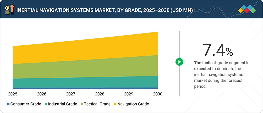
As of 2025, the navigation-grade segment accounted for the largest share in the market due to its high accuracy and reliability. These systems are mainly used in critical applications such as aircraft, naval vessels, and missile systems, where even small errors cannot be tolerated. The growing demand for high-performance navigation in defense and aerospace platforms is supporting the dominance of this segment.
As of 2025, the integrated GNSS/INS segment held the largest share as it offers improved accuracy and reliability by combining inertial systems with satellite navigation. These systems are widely used across military and commercial platforms to ensure continuous positioning, even in challenging environments. The ability to provide stable navigation in GPS-degraded conditions is driving their adoption.
As of 2025, the accelerometers segment held the largest share of the inertial navigation systems market, as it is a core component used to measure motion and velocity. Accelerometers are widely used across all types of INS applications, from high-end defense systems to commercial platforms. Their importance in calculating position and movement supports their strong market demand.
INERTIAL NAVIGATION SYSTEMS MARKET REGION
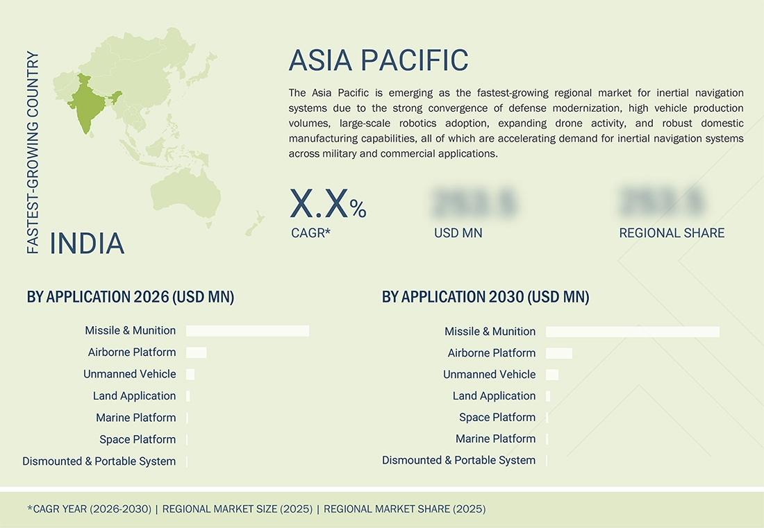
Asia Pacific to be fastest-growing region in inertial navigation systems market during forecast period
The Asia Pacific is emerging as the fastest-growing regional market for inertial navigation systems, driven by strong convergence of defense modernization, high vehicle production volumes, large-scale robotics adoption, expanding drone activity, and robust domestic manufacturing capabilities, all of which are accelerating demand across military and commercial applications.
INERTIAL NAVIGATION SYSTEMS MARKET SIZE, SHARE & ANALYSIS: COMPANY EVALUATION MATRIX
In the inertial navigation systems market matrix, Honeywell International Inc. (Star) holds a strong position due to its wide presence across both commercial and defense platforms. The company develops and supplies advanced inertial navigation and sensor solutions used in aircraft, military systems, and autonomous platforms. Its long-term relationships with major aerospace OEMs and defense organizations, along with strong integration capabilities, support its leadership in the market. General Electric Company (Emerging Leader) is gradually strengthening its position through developments in navigation and sensing technologies for aviation and defense applications. The company is involved in improving system performance and supporting next-generation platforms, which are helping expand its presence in the inertial navigation systems market.
Source: Secondary Research, Interviews with Experts, MarketsandMarkets Analysis
INERTIAL NAVIGATION SYSTEMS MARKET SCOPE
| REPORT METRIC | DETAILS |
|---|---|
| Market Size in 2025 (Value) | USD 8.87 Billion |
| Market Size in 2026 (Value) | USD 9.42 Billion |
| Market Forecast in 2030 (Value) | USD 11.92 Billion |
| CAGR | 6.1% |
| Years Considered | 2021–2030 |
| Base Year | 2025 |
| Forecast Period | 2026-2030 |
| Units Considered | Value (USD Million/Billion) |
| Report Coverage | Revenue forecast, company ranking, competitive landscape, growth factors, and trends |
| Segments Covered |
|
| Regions CoveredA12 | North America, Asia Pacific, Europe, Middle East, and Rest of the World |
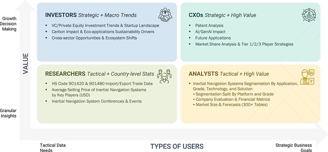
WHAT IS IN IT FOR YOU: INERTIAL NAVIGATION SYSTEMS MARKET SIZE, SHARE & ANALYSIS REPORT CONTENT GUIDE
DELIVERED CUSTOMIZATIONS
We have successfully delivered the following deep-dive customizations:
| CLIENT REQUEST | CUSTOMIZATION DELIVERED | VALUE ADDS |
|---|---|---|
| Leading Manufacturer | Additional segment breakdown for countries | Additional country-level market sizing tables for segments/sub-segments covered at the regional/global level to gain an understanding of market potential by each country |
| Emerging Leader | Additional company profiles | Competitive information on targeted players to gain granular insights into direct competition |
| Regional Market Leader | Additional country market estimates | Additional country-level deep dive for a more targeted understanding of the total addressable market |
RECENT DEVELOPMENTS
- September 2025 : The Space Development Agency awarded Northrop Grumman a contract worth USD 3.5 billion as part of the Tranche 3 missile tracking layer program for a proliferated low Earth orbit satellite constellation. The program will deploy advanced tracking satellites capable of detecting and tracking missile threats, supporting precision targeting and navigation within the US defense space architecture.
- July 2025 : Honeywell was selected by the US Department of Defense’s Defense Innovation Unit to participate in the Transition of Quantum Sensing program under contracts including CRUISE and QUEST. The work focuses on developing quantum sensor technologies that support next-generation inertial sensing and alternative positioning, navigation, and timing capabilities for military platforms.
- July 2025 : Exail secured a contract to supply 100 PHINS Compact inertial navigation systems for integration into unmanned underwater vehicles. The PHINS Compact INS provides high-precision navigation and maintains reliable performance in GNSS-denied maritime environments, enabling autonomous underwater vehicles to perform defense missions with improved operational flexibility.
- June 2023 : Wisk Aero (US), a leading advanced air mobility (AAM) company, entered into a contract with Safran Electronics & Defense to supply SkyNaute inertial navigation systems for its Generation 6 autonomous, all-electric air taxis.
Table of Contents
 Exclusive indicates content/data unique to MarketsandMarkets and not available with any competitors.
TITLE
PAGE NO
1
INTRODUCTION
15
2
EXECUTIVE SUMMARY
3
PREMIUM INSIGHTS
4
MARKET OVERVIEW
4.1
INTRODUCTION
4.2
MARKET DYNAMICS
4.2.1
DRIVERS
4.2.2
RESTRAINTS
4.2.3
OPPORTUNITIES
4.2.4
CHALLENGES
4.3
UNMET NEEDS AND WHITE SPACES
4.4
INTERCONNECTED MARKETS AND CROSS-SECTOR OPPORTUNITIES
4.5
STRATEGIC MOVES BY TIER 1/2/3 PLAYERS
5
INDUSTRY TRENDS
5.1
MACROECONOMIC OUTLOOK
5.1.1
INTRODUCTION
5.1.2
GDP TRENDS AND FORECAST
5.1.3
TRENDS IN GLOBAL INERTIAL NAVIGATION SYSTEMS INDUSTRY
5.2
VALUE CHAIN ANALYSIS
5.3
ECOSYSTEM ANALYSIS
5.4
INVESTMENT AND FUNDING SCENARIO
5.5
PRICING ANALYSIS
5.5.1
AVERAGE SELLING PRICE TREND, BY GRADE (2022-2025)
5.5.2
AVERAGE SELLING PRICE TREND, BY REGION (2022-2025)
5.6
TRADE ANALYSIS
5.6.1
IMPORT SCENARIO
5.6.2
EXPORT SCENARIO
5.7
KEY CONFERENCES AND EVENTS, 2026-2027
5.8
TRENDS/DISRUPTIONS IMPACTING CUSTOMER BUSINESS
5.9
CASE STUDY ANALYSIS
5.10
IMPACT OF 2025 US TARIFFS ON INERTIAL NAVIGATION SYSTEMS MARKET
5.10.1
INTRODUCTION
5.10.2
KEY TARIFF RATES
5.10.3
PRICE IMPACT ANALYSIS
5.10.4
IMPACT ON COUNTRIES/REGIONS
5.10.4.1
US
5.10.4.2
EUROPE
5.10.4.3
ASIA PACIFIC
5.10.5
IMPACT ON DIFFERENT APPLICATIONS
6
TECHNOLOGICAL ADVANCEMENTS, AI-DRIVEN IMPACT, PATENTS, INNOVATIONS, AND FUTURE APPLICATIONS
6.1
KEY EMERGING TECHNOLOGIES
6.2
COMPLEMENTARY TECHNOLOGIES
6.3
TECHNOLOGY/PRODUCT ROADMAP
6.4
PATENT ANALYSIS
6.5
FUTURE APPLICATIONS
6.6
IMPACT OF AI/GENERATIVE AI ON INERTIAL NAVIGATION SYSTEMS MARKET
6.6.1
TOP USE CASES AND MARKET POTENTIAL
6.6.2
CASE STUDIES OF AI IMPLEMENTATION IN INERTIAL NAVIGATION SYSTEMS MARKET
6.6.3
INTERCONNECTED ADJACENT ECOSYSTEM AND IMPACT ON MARKET PLAYERS
6.6.4
CLIENTS’ READINESS TO ADOPT GENERATIVE AI IN INERTIAL NAVIGATION SYSTEMS MARKET
6.7
OPERATIONAL DATA
7
SUSTAINABILITY AND REGULATORY LANDSCAPE
7.1
REGIONAL REGULATIONS AND COMPLIANCE
7.1.1
REGULATORY BODIES, GOVERNMENT AGENCIES, AND OTHER ORGANIZATIONS
7.1.2
REGULATORY FRAMEWORK
7.1.3
INDUSTRY STANDARDS
7.2
CERTIFICATIONS, LABELING, AND ECO-STANDARDS
8
CUSTOMER LANDSCAPE & BUYER BEHAVIOR
8.1
DECISION-MAKING PROCESS
8.2
BUYER STAKEHOLDERS AND BUYING EVALUATION CRITERIA
8.3
ADOPTION BARRIERS & INTERNAL CHALLENGES
8.4
UNMET NEEDS FROM VARIOUS END USERS
9
INERTIAL NAVIGATION SYSTEMS MARKET, BY APPLICATION (MARKET SIZE & FORECAST TO 2030-USD MILLION)
9.1
INTRODUCTION
9.2
COMPARISON OF VARIOUS INERTIAL NAVIGATION SYSTEMS APPLICATIONS BASED ON AUTONOMY LEVEL
9.2.1
FULLY AUTONOMOUS
9.2.2
SEMI-AUTONOMOUS
9.2.3
REMOTELY OPERATED
9.2.4
CREW OPERATED
9.3
MISSILE & MUNITION
9.3.1
MISSILE
9.3.1.1
BALLISTIC MISSILE
9.3.1.2
CRUISE MISSILE
9.3.1.3
INTERCEPTOR
9.3.2
GUIDED ROCKET
9.3.3
GUIDED AMMUNITION
9.3.3.1
MORTAR AMMUNITION
9.3.3.2
TANK AMMUNITION
9.3.3.3
ARTILERY AMMUNITION
9.3.3.4
NAVAL AMMUNITION
9.3.4
LOITERING MUNITION
9.3.5
TORPEDO
9.4
AIRBORNE PLATFORM
9.4.1
COMMERCIAL AIRCRAFT
9.4.1.1
NARROW-BODY
9.4.1.2
WIDE-BODY
9.4.1.3
REGIONAL JET
9.4.1.4
BUSINESS JET
9.4.1.5
COMMERCIAL HELICOPTER
9.4.1.6
LIGHT AIRCRAFT
9.4.2
MILITARY AIRCRAFT
9.4.2.1
FIGHTER JET
9.4.2.2
TRANSPORT AIRCRAFT
9.4.2.3
SPECIAL MISSION AIRCRAFT
9.4.2.4
MILITARY HELICOPTER
9.5
SPACE PLATFORM
9.5.1
SPACE LAUNCH VEHICLE
9.5.2
SATELLITE
9.6
MARINE PLATFORM
9.6.1
COMMERCIAL SURFACE VESSEL
9.6.2
MILITARY SURFACE VESSEL
9.6.3
OFFSHORE PLATFORMS
9.6.4
SUBMARINES
9.7
LAND APPLICATION
9.7.1
MILITARY VEHICLE
9.7.1.1
COMBAT VEHICLE
9.7.1.1.1
MAIN BATTLE TANK
9.7.1.1.2
INFANTRY FIGHTING VEHICLE
9.7.1.1.3
ARMORED PERSONAL CARRIER
9.7.1.1.4
ARMORED AMPHIBIOUS VEHICLE
9.7.1.1.5
MINE-RESISTANT AMBUSH VEHICLE
9.7.1.1.6
LIGHT ARMORED VEHICLE
9.7.1.2
COMBAT SUPPORT VEHICLE
9.7.1.2.1
ARMOURED SUPPLY TRUCK
9.7.1.2.2
ARMOURED COMMAND AND CONTROL VEHICLE
9.7.1.2.3
REPAIN & RECOVERY VEHICLE
9.7.1.2.4
BRIDGE-LAYING TANK
9.7.1.2.5
MINE CLEARANCE VEHICLE
9.7.1.3
FIRE SUPPORT & AIR-DEFENSE VEHICLE
9.7.1.3.1
SELF-PROPELLED ARTILLERY VEHICLE
9.7.1.3.2
AIR-DEFENSE VEHICLE
9.7.2
CIVIL & INDUSTRIAL MOBILE PLATFORM
9.7.2.1
ON-ROAD AUTONOMOUS VEHICLE
9.7.2.1.1
AUTONOMOUS PASSENGER VEHICLE
9.7.2.1.2
AUTONOMOUS PASSENGER SHUTTLE
9.7.2.1.3
AUTONOMOUS FREIGHT VEHICLE
9.7.2.2
OFF-ROAD INDUSTRIAL MOBILE
9.7.2.2.1
CONSTRUCTION MACHINERY
9.7.2.2.2
MINING MACHINERY
9.7.2.2.3
AGRICULTURAL MACHINERY
9.7.2.3
RAIL SYSTEM
9.7.2.3.1
PASSENGER RAIL
9.7.2.3.2
FREIGHT RAIL
9.7.2.3.3
RAIL TRACK INSPECTION & MEASUREMENT PLATFORM
9.7.2.3.4
RAIL MAINTENANCE-OF-WAY PLATFORM
9.7.3
INDUSTRIAL & MOBILE ROBOTIC
9.7.3.1
FIXED INDUSTRIAL ROBOT
9.7.3.2
AUTOMATED GUIDED VEHICLE
9.7.3.3
AUTONOMOUS MOBILE ROBOT
9.7.3.4
INDUSTRIAL MOBILE ROBOT
9.8
UNMANNED VEHICLE
9.8.1
UNMANNED AERIAL VEHICLE
9.8.2
UNMANNED GROUND VEHICLE
9.8.3
UNMANNED MARITIME VEHICLE
9.8.3.1
UNMANNED UNDERWATER VEHICLE
9.8.3.2
UNMANNED SURFACE VEHICLE
9.9
DISMOUNTED & PORTABLE SYSTEM
9.9.1
SOLDIER NAVIGATION & WEARABLE
9.9.2
HANDHELD/MANPACK POSITIONING UNIT
10
INERTIAL NAVIGATION SYSTEMS MARKET, BY GRADE (MARKET SIZE & FORECAST TO 2030-USD MILLION)
10.1
INTRODUCTION
10.2
PLATFORM DEPLOYMENT ARCHITECTURE COMPARISON OF GRADE APPLICATIONS
10.2.1
GIMBALED (STABLE PLATFORM INS)
10.2.2
STRAPDOWN (SINS)
10.3
CONSUMER-GRADE (> 10°/HR)
10.4
INDUSTRIAL-GRADE (1 TO 10°/HR)
10.5
TACTICAL-GRADE (0.1 TO 1 °/HR)
10.6
NAVIGATION-GRADE (0.01 TO 0.1°/HR)
11
INERTIAL NAVIGATION SYSTEMS MARKET, BY TECHNOLOGY (MARKET SIZE & FORECAST TO 2030-USD MILLION)
11.1
INTRODUCTION
11.2
CLASSIFICATION OF INERTIAL NAVIGATION SYSTEM CONFIGURATION BY NAVIGATION ARCHITECTURE
11.3
STANDALONE INERTIAL NAVIGATION SYSTEM
11.4
INTEGRATED GLOBAL NAVIGATION SATELLITE SYSTEM/INERTIAL NAVIGATION SYSTEM
11.5
HYBRID/MULTISENSOR-BASED INERTIAL NAVIGATION SYSTEMS
12
INERTIAL NAVIGATION SYSTEMS MARKET, BY SOLUTION (MARKET SIZE & FORECAST TO 2030-USD MILLION)
12.1
INTRODUCTION
12.2
ACCELEROMETER
12.3
GYROSCOPE
12.3.1
RING LASER GYRO
12.3.2
FIBER OPTIC GYRO
12.3.3
MICROELECTROMECHANICAL SYSTEM (MEMS)
12.3.4
OTHER TECHNOLOGIES (MECHANICAL, QUANTUM, HYBRID/INTEGRATED GYROS)
12.4
ALGORITHM & PROCESSOR
12.5
OTHER COMPONENTS
13
INERTIAL NAVIGATION SYSTEMS MARKET, BY REGION (MARKET SIZE & FORECAST TO 2030-USD MILLION)
13.1
INTRODUCTION
13.2
NORTH AMERICA
13.2.1
US
13.2.2
CANADA
13.3
EUROPE
13.3.1
FRANCE
13.3.2
GERMANY
13.3.3
UK
13.3.4
ITALY
13.3.5
RUSSIA
13.3.6
REST OF EUROPE
13.4
ASIA PACIFIC
13.4.1
CHINA
13.4.2
INDIA
13.4.3
JAPAN
13.4.4
SOUTH KOREA
13.4.5
REST OF ASIA PACIFIC
13.5
MIDDLE EAST
13.5.1
GCC
13.5.1.1
UAE
13.5.1.2
SAUDI ARABIA
13.5.2
REST OF MIDDLE EAST
13.6
REST OF THE WORLD
13.6.1
LATIN AMERICA
13.6.2
AFRICA
14
COMPETITIVE LANDSCAPE
14.1
INTRODUCTION
14.2
KEY PLAYER STRATEGIES/RIGHT TO WIN
14.3
REVENUE ANALYSIS
14.4
MARKET SHARE ANALYSIS
14.5
BRAND COMPARISON
14.6
COMPANY VALUATION AND FINANCIAL METRICS
14.7
COMPANY EVALUATION MATRIX: KEY PLAYERS,
14.7.1
STARS
14.7.2
EMERGING LEADERS
14.7.3
PERVASIVE PLAYERS
14.7.4
PARTICIPANTS
14.7.5
COMPANY FOOTPRINT, KEY PLAYERS,
14.7.5.1
COMPANY FOOTPRINT
14.7.5.2
REGION FOOTPRINT
14.7.5.3
TECHNOLOGY FOOTPRINT
14.7.5.4
APPLICATION FOOTPRINT
14.7.5.5
GRADE FOOTPRINT
14.8
COMPANY EVALUATION MATRIX: STARTUPS/SMES,
14.8.1
PROGRESSIVE COMPANIES
14.8.2
RESPONSIVE COMPANIES
14.8.3
DYNAMIC COMPANIES
14.8.4
STARTING BLOCKS
14.8.5
COMPETITIVE BENCHMARKING: STARTUPS/SMES,
14.8.5.1
LIST OF KEY STARTUPS/SMES
14.8.5.2
COMPETITIVE BENCHMARKING OF KEY STARTUPS/SMES
14.9
COMPETITIVE SCENARIO
14.9.1
PRODUCT LAUNCHES
14.9.2
DEALS
14.9.3
OTHER DEVELOPMENTS
15
COMPANY PROFILES
15.1
KEY PLAYERS
15.1.1
SAFRAN ELECTRONICS & DEFENSE
15.1.2
NORTHROP GRUMMAN
15.1.3
TELEDYNE TECHNOLOGIES INC
15.1.4
COLLINS AEROSPACE
15.1.5
GENERAL DYNAMICS CORPORATION
15.1.6
GENERAL ELECTRIC COMPANY
15.1.7
TRIMBLE INC
15.1.8
L3HARRIS TECHNOLOGIES, INC.
15.1.9
HONEYWELL INTERNATIONAL INC.
15.1.10
EXAIL TECHNOLOGIES
15.1.11
MEMSIC SEMICONDUCTOR CO., LTD
15.1.12
THALES
15.1.13
ISRAEL AEROSPACE INDUSTRIES LTD.
15.1.14
EMCORE CORPORATION
15.2
OTHER PLAYERS
16
RESEARCH METHODOLOGY
16.1
RESEARCH DATA
16.1.1
SECONDARY DATA
16.1.1.1
KEY DATA FROM SECONDARY SOURCES
16.1.2
PRIMARY DATA
16.1.2.1
KEY DATA FROM PRIMARY SOURCES
16.1.2.2
KEY PRIMARY PARTICIPANTS
16.1.2.3
BREAKDOWN OF PRIMARIES
16.1.2.4
KEY INDUSTRY INSIGHTS
16.2
MARKET SIZE ESTIMATION
16.2.1
BOTTOM-UP APPROACH
16.2.2
TOP-DOWN APPROACH
16.2.3
BASE NUMBER CALCULATION
16.3
MARKET FORECAST APPROACH
16.3.1
SUPPLY SIDE
16.3.2
DEMAND SIDE
16.4
RESEARCH ASSUMPTIONS
16.5
RESEARCH LIMITATIONS AND RISK ASSESSMENT
17
APPENDIX
17.1
DISCUSSION GUIDE
17.2
KNOWLEDGESTORE: MARKETSANDMARKETS’ SUBSCRIPTION PORTAL
17.3
CUSTOMIZATION OPTIONS
17.4
RELATED REPORTS
17.5
AUTHOR DETAILS
Methodology
The study involved four major activities in estimating the current size of the inertial navigation systems market. Exhaustive secondary research was done to collect information on the market, its adjacent markets, and its parent market. The next step was to validate these findings, assumptions, and sizing with industry experts across the value chain through primary research. Demand-side analysis was conducted to estimate the overall market size. After that, market breakdown and data triangulation procedures were employed to estimate the sizes of various segments and subsegments within the inertial navigation systems market.
Secondary Research
During the secondary research process, various sources were consulted to identify and collect information for this study. The secondary sources included government sources, such as SIPRI, corporate filings, including annual reports, press releases, and investor presentations from companies, white papers, journals and certified publications, and articles from recognized authors, directories and databases.
Primary Research
Extensive primary research was conducted after acquiring information regarding the inertial navigation systems market scenario through secondary research. Several primary interviews were conducted with market experts from the demand and supply sides across major countries of North America, Europe, the Asia Pacific, the Middle East, and the Rest of the world. Primary data was collected through questionnaires, emails, and telephonic interviews.

To know about the assumptions considered for the study, download the pdf brochure
Market Size Estimation
The top-down and bottom-up approaches were used to estimate and validate the size of the inertial navigation systems market. The research methodology used to estimate the size of the market included the following details:
- Key players in the market were identified through secondary research, and their market shares were determined through a combination of primary and secondary research. This included a study of the annual and financial reports of the top market players, as well as extensive interviews with leaders, including directors, engineers, marketing executives, and other key stakeholders of leading companies operating in the market.
- All percentage shares, splits, and breakdowns were determined using secondary sources and verified through primary sources.
- All possible parameters that affect the markets covered in this research study were accounted for, viewed in extensive detail, verified through primary research, and analyzed to obtain the final quantitative and qualitative data on the inertial navigation systems market. This data was consolidated, enhanced with detailed inputs, analyzed by MarketsandMarkets, and presented in this report.
Inertial Navigation Systems Market: Top-Down and Bottom-Up Approach

Data Triangulation
After determining the overall market size, the total market was divided into several segments and subsegments. The data triangulation and market breakdown procedures explained below were implemented, wherever applicable, to complete the overall market engineering process and arrive at the estimated market numbers for the market segments and subsegments. The data was triangulated by studying various factors and trends from the demand and supply sides. Additionally, the market size was validated using top-down and bottom-up approaches.
Market Definition
An inertial navigation system evaluates inputs from accelerometers and gyroscopes to track the position and orientation of an object relative to its starting point and velocity. These systems are utilized across airborne, ground, and naval platforms. Position, velocity, and orientation are essential parameters of navigation systems. Most navigation systems, such as the global positioning system (GPS), do not provide real-time details on the above-mentioned parameters. The deployment of GPS across various platforms depends on its signal strength and the equipment’s location. Additionally, precise and reliable navigation inputs are required to ensure the efficient functioning of GPS and other satellite communication and airborne equipment. Inertial navigation systems provide these details with the desired accuracy and reliability.
Key Stakeholders
- Inertial Navigation System Manufacturers
- Inertial Navigation System Wholesalers, Retailers, and Distributors
- System Integrators
- Technology Providers
- Sensor Manufacturers
- Raw Material Suppliers
- Aircraft Regulatory Bodies
Report Objectives
- To define, describe, and forecast the inertial navigation systems market based on application, grade, technology, and solution
- To forecast the size of different segments of the market with respect to North America, Europe, the Asia Pacific, the Middle East, and the Rest of the World
- To identify and analyze the drivers, restraints, opportunities, and challenges influencing the growth of the market
- To identify industry trends, market trends, and technology trends currently prevailing in the market
- To analyze micro markets with respect to individual growth trends, prospects, and their contribution to the overall market
- To analyze the degree of competition in the market by analyzing recent developments adopted by leading market players
- To provide a detailed competitive landscape of the market, along with a ranking analysis of key players, and an analysis of startup companies in the market
- To strategically profile the key market players and comprehensively analyze their core competencies
- To provide a detailed competitive landscape of the market, along with a market share analysis and revenue analysis of key players
Available customizations:
MarketsandMarkets offers the following customizations for this market report:
- Additional country-level analysis of the inertial navigation systems market
- Profiling of other market players (up to 5)
Product Analysis
- Product matrix, which provides a detailed comparison of the product portfolio of each company in the inertial navigation systems market
Key Questions Addressed by the Report
The inertial navigation systems market is estimated at USD 9.42 billion in 2026 and is projected to reach USD 11.92 billion by 2030, growing at a CAGR of 6.1% during the forecast period.
North America holds the largest share of the inertial navigation systems market due to strong demand from defense and aerospace sectors and increasing adoption in aircraft, missiles, and submarines.
The aircraft segment dominates the market by platform due to high demand for precise navigation in aviation, while the defense segment leads by end user due to extensive use in military applications such as missile guidance and reconnaissance.
The inertial navigation systems market is segmented by platform into aircraft, missiles, marine, space launch vehicles, military armored vehicles, and unmanned systems, and further by component, technology, grade, end user, and region.
Key players in the inertial navigation systems market include Safran Electronics & Defense, Northrop Grumman, Teledyne Technologies Inc., Collins Aerospace, and Honeywell International Inc., which are actively contributing to innovation and market growth.
⚡ Growth Signals
Personalize This Research
- Triangulate with your Own Data
- Get Data as per your Format and Definition
- Gain a Deeper Dive on a Specific Application, Geography, Customer or Competitor
- Any level of Personalization
Let Us Help You
- What are the Known and Unknown Adjacencies Impacting the Inertial Navigation Systems Market
- What will your New Revenue Sources be?
- Who will be your Top Customer; what will make them switch?
- Defend your Market Share or Win Competitors
- Get a Scorecard for Target Partners

Leading technology innovator in Aerospace and Defense
MarketsandMarkets has been crucial to our research findings and so far, they are the best source we've been able to locate. I'm sure nobody has the predictions nailed, but they seem to know it better than most.
Still Researching the Inertial Navigation Systems Ecosystem?
Before you go, explore the intelligence strategy teams use to analyze this market.
- Inertial Navigation Systems Competitor Landscape
- Inertial Navigation Systems Technology Shifts
- Inertial Navigation Systems supply consulting-grade strategic intelligence outputs tailored to your Inertial Navigation Systems growth question.
Generate 15+ consulting-grade strategic intelligence outputs tailored to your Inertial Navigation Systems growth question.
