


Image of the Day for July 9, 2026
The third category 5 tropical cyclone of 2026 crossed the U.S. Northern Mariana Islands and Guam before continuing toward Asia.
Jul 09, 2026
View more Images of the Day:
In early July 2026, for the second time in three months, a powerful typhoon crossed the U.S. Northern Mariana Islands and Guam in the North Pacific Ocean. Super Typhoon Bavi was at peak intensity when it neared the islands on the night of July 5, bringing winds of 290 kilometers (180 miles) per hour, along with torrential rain and dangerous storm surge.
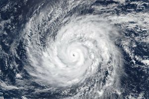
This nighttime image, captured by the VIIRS (Visible Infrared Imaging Radiometer Suite) on the NOAA-20 satellite, shows Bavi’s eye at about 15:30 Universal Time on July 5 (1:30 a.m. local time on July 6). Light from the Moon, which was in the waning gibbous phase, illuminates the eyewall’s western side. The eye passed over Rota, north of Guam, several hours after the image was acquired.
Bavi became a super typhoon in the early hours of July 4 local time while tracking west over the warm ocean. Satellite observations indicated that sea surface temperatures were around 30 degrees Celsius (86 degrees Fahrenheit) in the region. Bavi was the third tropical cyclone in 2026 to reach category 5 intensity on the Saffir-Simpson wind scale.
The typhoon caused extensive damage across Guam, Rota, and Saipan, according to news reports, downing power poles and lines; flooding roads and littering them with debris; and damaging buildings, including a water distribution station on Rota. U.S. Coast Guard crews worked to clear navigation hazards in the waterways around Guam and the Northern Marianas and reopen ports as dangerous marine conditions subsided, according to reports. This damage comes on top of destructive winds and flooding from Super Typhoon Sinlaku, which crossed the islands in mid-April.
On July 8, Bavi remained a powerful typhoon as it moved west over the Philippine Sea. In the early afternoon, when the image above was captured, the National Weather Service reported maximum sustained wind speeds of 250 kilometers (155 miles) per hour. Forecasts indicated the typhoon’s track could bend northwest toward Taiwan, the Ryukyu Islands of southern Japan, and mainland China and weaken over the next several days.
Writing in Yale Climate Connections, meteorologist Jeff Masters said that Bavi is the type of storm that might be expected when a strong El Niño event is building, which is currently the case. El Niño-year typhoons may form farther east, giving them more time over warm water to intensify before curving toward Asia, Masters explained, “resulting in a greater chance of reaching Category 5 intensity.”
NASA Earth Observatory images by Michala Garrison, using data from NASA EOSDIS LANCE, GIBS/Worldview, and the Joint Polar Satellite System (JPSS), and hurricane track data from the U.S. Naval Research Laboratory. Story by Lindsey Doermann.
Downloads
July 5, 2026
July 8, 2026
- CIMSS Satellite Blog (2026, July 3) Super Typhoon Bavi rapidly intensifies to a Category 5 storm east of Guam, eventually passing just north of the island of Rota. Accessed July 8, 2026.
- Military.com (2026, July 7) Coast Guard Works to Reopen Guam, CNMI Ports After Super Typhoon Bavi. Accessed July 8, 2026.
- NASA Earth Observatory (2026, April 14) Super Typhoon Sinlaku. Accessed July 8, 2026.
- National Weather Service (2026, July 8) Public Tropical Cyclone Advisory. Accessed July 8, 2026.
- Weather Underground (2026, July 8) Super Typhoon Bavi. Accessed July 8, 2026.
- Yale Climate Connections (2026, July 3) Super Typhoon Bavi becomes the 3rd Cat 5 of 2026. Accessed July 8, 2026.
You may also be interested in:
Stay up-to-date with the latest content from NASA as we explore the universe and discover more about our home planet.
Super Typhoon Sinlaku
3 min read
The violent storm aimed at the U.S. Northern Mariana Islands and Guam in mid-April 2026.

Typhoon Jangmi
2 min read
The sprawling storm promised to deliver torrential rain across a wide swath of southern Japan.

Gravity Waves From Super Typhoon Sinlaku
4 min read
Satellites observed striking upper-atmosphere phenomena generated by an intensifying tropical cyclone.
Keep Exploring