


惯性聚合 高效追踪和阅读你感兴趣的博客、新闻、科技资讯
阅读原文 在惯性聚合中打开

推荐订阅源

Stack Overflow Blog
Stack Overflow Blog
Recent Announcements
Microsoft Security Blog
L
LINUX DO - 最新话题
P
Privacy & Cybersecurity Law Blog
Google DeepMind News
Security Archives - TechRepublic
云风的 BLOG
云风的 BLOG
酷 壳 – CoolShell
酷 壳 – CoolShell
博客园 - Franky
PCI Perspectives
PCI Perspectives
OSCHINA 社区最新新闻
OSCHINA 社区最新新闻
TaoSecurity Blog
TaoSecurity Blog
CTFtime.org: upcoming CTF events
Attack and Defense Labs
Threat Intelligence Blog | Flashpoint
P
Proofpoint News Feed
小众软件
小众软件
A
Arctic Wolf
C
Cybersecurity and Infrastructure Security Agency CISA
F
Fortinet All Blogs
T
Threatpost
Security Latest
Security Latest
V
Vulnerabilities – Threatpost
B
Blog RSS Feed
MongoDB | Blog
MongoDB | Blog
WordPress大学
WordPress大学
Forbes - Security
Forbes - Security
H
Hackread – Cybersecurity News, Data Breaches, AI and More
C
CERT Recently Published Vulnerability Notes
AI
AI
博客园 - 三生石上(FineUI控件)
T
Threat Research - Cisco Blogs
Recent Commits to openclaw:main
S
Schneier on Security
I
Intezer
The GitHub Blog
The GitHub Blog
cs.AI updates on arXiv.org
V
V2EX
aimingoo的专栏
aimingoo的专栏
量子位
NISL@THU
NISL@THU
N
News and Events Feed by Topic
O
OpenAI News
Microsoft Azure Blog
C
Check Point Blog
Schneier on Security
S
Secure Thoughts
The Cloudflare Blog
J
Java Code Geeks

Steve Bennett blogs

Whenever: exploring times and places in film and books Alternative Earth: a procedurally generated map using vector tiles Host your own vector tile server on Glitch Building TinyMap: an itty bitty collaborative mapping tool You might not need PostGIS: streamlined vector tile processing for big map visualisations OpenStreetMap vector tiles: mixing and matching engines, schemas and styles 2015’s proudest moments Your own personal National Map with TerriaJS: no coding and nothing to deploy After the hackathon: 4 classic recipes OpenTrees.org: how to aggregate 373,000 trees from 9 open data sources Cycletour.org: a better map for Australian cycle tours Normalize cross-tabs for Tableau: a free Google Sheets tool 7 reasons to release that government dataset The Data Guru in Residence Chromecast in the real world: six casting workflows Web map projections: the bare minimum you need to know Multivariate binary symbol maps with TileMill. The Australian’s menacing editorial Git: what they didn’t tell you One week of Salt: frustrations and reflections. Super lightweight map websites with Github Digital humanities for beginners: get started with the Trove API Trello Tennis Terrain in TileMill: a walkthrough for non-GIS types A TileMill server with all the trimmings Forget trying to remember your servers’ names! Anonymous longitudinal surveys with LimeSurvey Windows red cross errors scam What I learned at e-Research Australasia 2012 A pattern for multi-instrument data harvesting with MyTardis Getting started with Chef on the NeCTAR Research Cloud How OData will solve data sharing and reuse for e-Research 10 things I hate about Git Semantic Google keywords Improving on the “administration rights required” workflow Why is buying stuff from eBay so complicated? Introducing: Cooking for engineers New Gmail feature: auto mailing list management Penny Auctions – a bit of analysis Hello world!
Cycletouring and OpenStreetMapping: a beautiful symbiosis
steveko · 2014-03-16 · via Steve Bennett blogs

Posted by on March 16, 2014

Contributing to OpenStreetMap is diversely rewarding: you help other people, you make open data as a whole more viable, you learn a lot about the area you’re mapping, and it’s fun. But sometimes it’s just plain pragmatic. Last weekend, I organised a cycle tour from Bendigo to Avenel, via the O’Keefe Rail Trail, Lake Eppalock, Colbinabbin, Rushworth, Murchison and Nagambie. When I started planning the route, OpenStreetMap looked like this:

Image

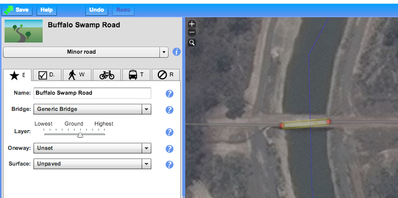
The major features are all there, but what’s missing is what matters most to cycle tourists: quiet country roads, and road surfaces. Is there a way to get from Eppalock to Colbinabbin on only sealed roads? Is Buffalo Swamp Rd (near Murchison) really sealed? A great way for me to research is to add to OpenStreetMap: use aerial imagery to add new roads, paying attention to whether they look sealed or not from the air.
Image

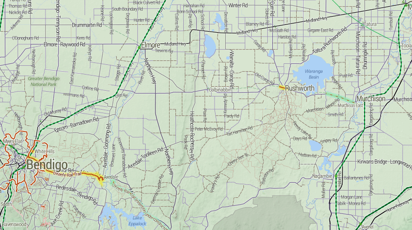
So Buffalo Swamp Road is obviously not sealed after all. By the time I was done, the map of the area looked like this:
Image

Notice how many “sealed” roads have turned out to be dirt, but also how many other unmapped little roads have been added to the map.

Once this is done, the steps are:

  1. Finalise the route, using OSRM.
  2. Send GPX files to everyone on the trip
  3. Load the GPX files onto both my GPS and Maverick Pro, an Android App
  4. Also load the cycletour.org tiles into Maverick
  5. Ride
  6. Update OpenStreetMap afterwards with any fresh information – obstacles, unexpected connections, local businesses, and so on.

There’s still lots more to add, but it’s nice that just planning this one trip has significantly improved coverage in a whole region like this.