


惯性聚合 高效追踪和阅读你感兴趣的博客、新闻、科技资讯
阅读原文 在惯性聚合中打开

推荐订阅源

C
Check Point Blog
宝玉的分享
宝玉的分享
V
Visual Studio Blog
B
Blog RSS Feed
G
Google Developers Blog
U
Unit 42
让小产品的独立变现更简单 - ezindie.com
P
Palo Alto Networks Blog
月光博客
月光博客
cs.AI updates on arXiv.org
L
LINUX DO - 最新话题
cs.CV updates on arXiv.org
小众软件
小众软件
GbyAI
GbyAI
L
LangChain Blog
A
About on SuperTechFans
Attack and Defense Labs
T
Tor Project blog
AWS News Blog
AWS News Blog
S
Security @ Cisco Blogs
H
Hacker News: Front Page
S
SegmentFault 最新的问题
Engineering at Meta
Engineering at Meta
The Register - Security
Recorded Future
Recorded Future
D
Darknet – Hacking Tools, Hacker News & Cyber Security
Hacker News - Newest:
Hacker News - Newest: "LLM"
V2EX - 技术
V2EX - 技术
H
Heimdal Security Blog
Simon Willison's Weblog
Y
Y Combinator Blog
Spread Privacy
Spread Privacy
奇客Solidot–传递最新科技情报
奇客Solidot–传递最新科技情报
WordPress大学
WordPress大学
P
Privacy International News Feed
I
Intezer
W
WeLiveSecurity
钛媒体:引领未来商业与生活新知
钛媒体:引领未来商业与生活新知
Help Net Security
Help Net Security
NISL@THU
NISL@THU
D
DataBreaches.Net
Stack Overflow Blog
Stack Overflow Blog
Exploit-DB.com RSS Feed
V
Vulnerabilities – Threatpost
N
News | PayPal Newsroom
Security Archives - TechRepublic
Google DeepMind News
The Hacker News
The Hacker News
L
Lohrmann on Cybersecurity
Schneier on Security

Steve Bennett blogs

Whenever: exploring times and places in film and books Alternative Earth: a procedurally generated map using vector tiles Host your own vector tile server on Glitch You might not need PostGIS: streamlined vector tile processing for big map visualisations OpenStreetMap vector tiles: mixing and matching engines, schemas and styles 2015’s proudest moments Your own personal National Map with TerriaJS: no coding and nothing to deploy After the hackathon: 4 classic recipes OpenTrees.org: how to aggregate 373,000 trees from 9 open data sources Cycletour.org: a better map for Australian cycle tours Normalize cross-tabs for Tableau: a free Google Sheets tool 7 reasons to release that government dataset The Data Guru in Residence Chromecast in the real world: six casting workflows Web map projections: the bare minimum you need to know Multivariate binary symbol maps with TileMill. The Australian’s menacing editorial Cycletouring and OpenStreetMapping: a beautiful symbiosis Git: what they didn’t tell you One week of Salt: frustrations and reflections. Super lightweight map websites with Github Digital humanities for beginners: get started with the Trove API Trello Tennis Terrain in TileMill: a walkthrough for non-GIS types A TileMill server with all the trimmings Forget trying to remember your servers’ names! Anonymous longitudinal surveys with LimeSurvey Windows red cross errors scam What I learned at e-Research Australasia 2012 A pattern for multi-instrument data harvesting with MyTardis Getting started with Chef on the NeCTAR Research Cloud How OData will solve data sharing and reuse for e-Research 10 things I hate about Git Semantic Google keywords Improving on the “administration rights required” workflow Why is buying stuff from eBay so complicated? Introducing: Cooking for engineers New Gmail feature: auto mailing list management Penny Auctions – a bit of analysis Hello world!
Building TinyMap: an itty bitty collaborative mapping tool
steveko · 2019-12-15 · via Steve Bennett blogs

Posted by on December 15, 2019

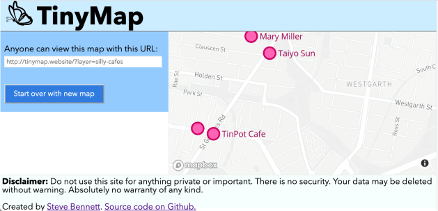
At FOSS4G Oceania 2019, I lamented the lack of free tools for collaboratively maintaining small datasets of locations, a common need in many community groups. So, this weekend I had a go at building one: TinyMap! A simple tool that lets you add and remove points with names and descriptions from any map you care to name.

Design goals:

  • Zero-cost to host.
  • Shave every possible corner on implementation effort (security, scalability, performance…)
  • Get it done in a weekend.

Learning authentication seemed more like work than fun, so I’ve decided to rely on secret URLs as the only security mechanism. The burden of choosing an unguessable URL, and not distributing it, lies entirely on the users. I’m sure this will end well.
Screen Shot 2019-12-15 at 9.18.39 pm.png

Back end

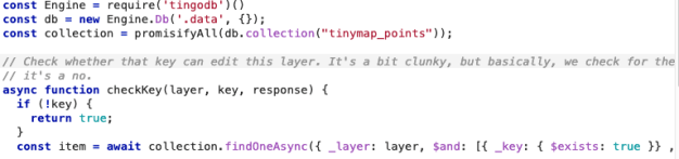
For storing and retrieving a few hundred points, running PostGIS seems overkill. Even using a hosted NoSQL solution like FireBase felt much too serious. I really wanted the NoSQL equivalent of SQLite, and eventually found TingoDB, which is basically MongoDB but in pure NodeJS.
Screen Shot 2019-12-15 at 9.22.41 pm

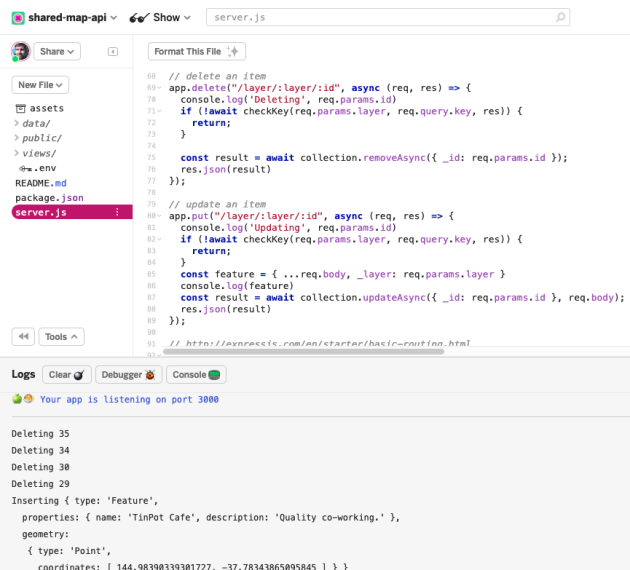
Writing an API wrapper around it with Express is pretty easy. I don’t write many servers, but the Express documentation is always such a pleasure to use. Just under 100 lines of code to provide CRUD services and very basic authentication.

Screen Shot 2019-12-15 at 9.24.55 pm

And where to host? On my favourite free NodeJS hosting platform, Glitch. It can sometimes feel a bit weird writing code directly in the browser, but it’s really nice skipping directly over the questions of “where should I host this?”, “how do I get my code there?” and “how do I make the server accessible to the outside world?”. Glitch makes for insane levels of productivity: just clone the Express starter project, and go – it’s already running.
Screen Shot 2019-12-15 at 9.28.27 pm

We end up with an API structure like:

You can see the code here: https://glitch.com/edit/#!/shared-map-api

Front end

The front end builds on my “community-map” VueJS template which provides a basic app structure, with the Tachyons CSS kit, and initialises a Mapbox-GL-JS map enhanced with my mapbox-gl-utils library and primed to deploy to Github Pages. I wanted to keep it as simple as possible.

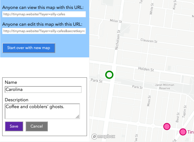
Three URL structures are understood:

  • /?layer=layername&secretkey=mysecret: user can add and delete features on the “layername” layer.
  • /?layer=layername: user can view features on the layername layer
  • /: user is invited to create a new map.

Interaction code can be surprisingly verbose to write. The simple mechanic of “click add, click the map, type a name and description, click save” immediately spawns questions such as “what if the user wants to cancel?” and “what if the user clicks on an existing point while they’re meant to be adding a new one?”
Screen Shot 2019-12-15 at 9.51.07 pm

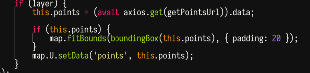
For simplicity, I’ve been trying to avoid storing any information about the map itself – only the points themselves are stored. That means, there’s no way to define where you want the viewpoint to be centred. My sneaky solution to that is to always centre it around where the points are.
Screen Shot 2019-12-15 at 9.46.25 pm

There is absolutely no error handling. If you enter an incorrect secret key, there is no warning – mostly because I didn’t have a method offhand for flashing an alert.

There is also no way to edit an existing item (yet).  Or to add any fields other than Name and Description. (Now it’s possible to existing items :) )

Front-end hosting is easy to set up on Github Pages. I like to put a domain name on even weekend hack projects, so, inspired by too many episodes of TinyHouse Nation, I went with tinymap.website.

The front-end code is on Github: https://github.com/stevage/tinymap/

Conclusion

Cutting corners is so liberating. If you’re not actually building the next great SaaS, perhaps you don’t need a high performance database. Maybe you don’t need Kubernetes, and a tiny service running on Glitch will do.

I’m not sure what happens next with TinyMap. If you like it, let me know!