








How often do you look down and wonder who created the path your feet are following? Or ask the cause of its curves and dips? Formed over thousands of years, paths form an “internet of feet” – a web of bridleways and hollow ways, drove roads and ridgeways, coffin tracks, pilgrimage trails and city pavements. Whether you’re hiking a National Trail or pottering along a National Trust footpath, there’s a good chance you’re following ancestral steps.
It’s thoughts like these that led me on a journey to track the evolution of British paths for my book, The Path More Travelled. Eleven thousand years ago ice age hunter-gatherers arrived from Europe’s heartlands, moving through the wilderness along broad “routeways”, that later widened to tracks when horses and then wheels were adopted in the bronze age. For more than 2,000 years, traffic moved no faster than the speed of a horse, until the internal combustion engine drove pedestrians off the road just over a century ago.
In search of the capillaries that gave life to every community in Britain, I revisited coast paths, tramped shepherds’ trails and followed the serpentine curls of rivers. Here are a few of my favourite paths that bring history to life.
Sweet Track, Somerset Levels
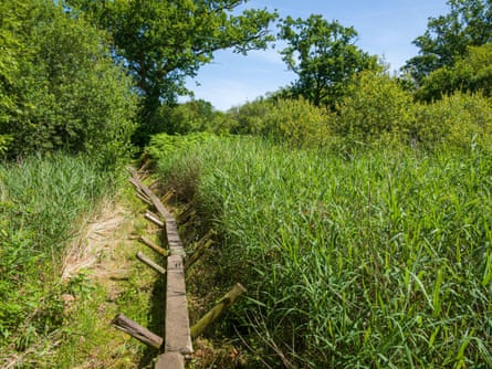
The hunt for prehistoric paths took me deep into the wetlands of the Somerset Levels, where the Sweet Track was discovered in 1970. Built nearly 6,000 years ago (3806BC) by early farmers who needed access to an island, the collapsed boardwalk was preserved in peat. But a short walk from the Avalon Marshes centre (with an excellent cafe and open-air museum), woodland paths explore Shapwick Heath nature reserve, where a replica section of the Sweet Track teeters through the reeds. Visitors can walk in single file along this narrow, timber causeway and imagine the world of the Neolithic pioneers who colonised Somerset’s reflective waterways long before they were drained and converted to farmland. For modern versions of the Sweet Track, visit the Norfolk Broads and Norfolk coast path, where stilted, planked boardwalks wend their way through reedbeds, salt marshes and swamp woodland known locally as alder carr.
Street of the Dead, Iona
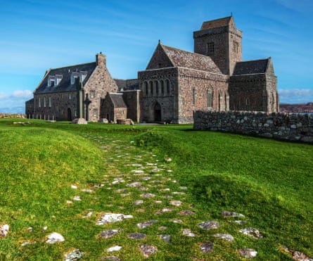
Writing this book led me to the far west of Scotland and the tiny island of Iona, where, after decades of tramping Britain’s paths, I walked for the first time along Sràid nam Marbh, the Street of the Dead. Across Britain, coffin roads, or corpse ways, were used by remote communities to convey their dead to cemeteries. Iona’s is no more than a few hundred metres in length, and most of it takes the form of a narrow, kinking lane leading from the ancient landing beach of Port nam Mairtear (Martyr’s Bay) to the site of a monastery founded in 563. Along this ancient road came the bodies of great Gaelic lords, bound for burial close to the monastery. For many, it’s a “thin place”, where the space between this world and the next narrows. You pass the ruins of an Augustinian nunnery established in around 1200, and the MacLean’s Cross, whose intricately carved floral and animal motifs and outstretched Christ captivated pilgrims. Then the abbey appears and the Street of the Dead, angling across the grass, the final section a short avenue of red granite slabs, sunken by the weight of time into the turf of the abbey precinct. There are very few roads in Britain where you can place your feet on to slabs that have been trodden by so many generations.
Bure Valley Path, Norfolk
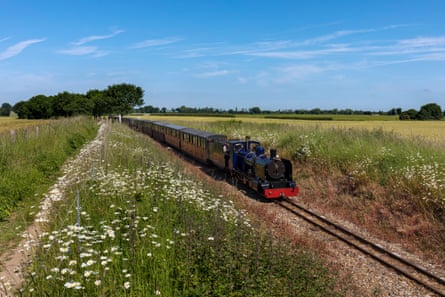
One of my favourite walks traces the banks of the River Bure between the market town of Aylsham and the railway village of Hoveton. It’s a typical, gentle Norfolk valley of slow meanders, cascading willows, kingfishers and herons. It was like this 100 years ago, when huge timber sailing barges, wherries, used to glide silently upriver to Aylsham’s mills. Close to the river ran a steam railway line linking Hoveton and Aylsham. Today, the nine-mile Bure Valley Path is a shared walking and cycling route that follows the course of the old railway, now relaid as a narrow-gauge steam line, the Bure Valley Railway. Cycling the path is fun, but a superb walk awaits those who take the steam train from Hoveton to Aylsham then walk back towards Hoveton on the Bure Valley Path for about two miles, where a footpath on the left drops down to the waterside church of St Mary’s in Burgh-next-Aylsham. From here, riverside footpaths head downstream past white-painted watermills and old navigation locks while occasional steam locomotives contribute to the sylvan backdrop. At Coltishall, you can rehydrate at The Rising Sun, stroll along Anchor Street where wherries were built, and then return to the Bure Valley Path for the final two miles back to Hoveton. I know of no other walk so closely related to the eras of wind and steam.
The Ridgeway, Hertfordshire to Wiltshire
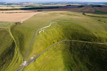
The Ridgeway runs for 87 miles from Ivinghoe Beacon high in the Chiltern Hills to the prehistoric stone circle at Avebury in deepest Wiltshire. On its rolling heights, you can walk back to the iron age, when formidable hill forts commanded the vales. The ghosts of warrior-farmers can be sensed most powerfully on the western end of the Ridgeway, where the chalky trail climbs past the ramparts of Uffington, whose banks and ditches – once braced with timber and chalk rubble – enclose an area twice the size of a football pitch. Right beside the fort, a 110-metre long white horse gallops across the down, cut deep into the turf during the late bronze age or early iron age. One mile to the west, the Ridgeway passes the chambered long barrow known as Wayland’s Smithy, which once contained the remains of 14 people dated to between 3590 and 3550BC. The Ridgeway’s knack of time travel has long appealed to writers and photographers, from Thomas Hardy and Richard Jefferies, to Richard Mabey and Fay Godwin, whose book The Oldest Road: The Ridgeway (1975), unravelled the path connecting deep history with a modern national trail.
Holloways, Surrey Hills
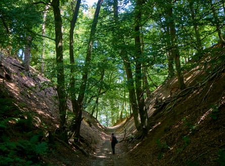
A holloway is a sunken path, an old way worn into the land by centuries of feet and hooves. Holloway walls can be almost vertical, cut back to raw rock and roots. Some are like ravines. Others are virtual tunnels, roofed with living trees. Some appear unexpectedly as gentle troughs in the landscape. They occur most dramatically in softer geologies like chalk, sandstone and greensand. Most are just a few minutes’ walk in length, but there are parts of the country where exploration will produce some very enjoyable clusters. There are three modest holloways right beside the White Horse of Uffington on the Ridgeway, cut perhaps in prehistoric times by cattle being moved from their winter quarters in the vale to the summer grasses of the high downs. In Holloway (2012), Robert Macfarlane wrote poetically of a buried path in the Chideock valley of south Dorset that it’s become a cause of pilgrimage for those of us who look for these places. The Surrey Hills are laced with secretive holloways. Among my favourites are the sunken tracks on the greensand of Leith Hill and farther west, the old holloways of Hascombe Hill and Hydon’s Ball. It’s along these semi-subterranean trackways that you’re most likely to detect the steady plod of Saxon cattle. Or Hobbits.
The Mass Trespass Walk, Derbyshire
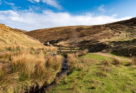
The story of countryside access is written in the grit of Kinder Scout, whose frowning sandstone forms the highest point in the Peak District. In April, 1932, an excited gaggle of hikers climbed the footpath from the Derbyshire village of Hayfield up towards the brow of Kinder Scout, where they clashed with squads of gamekeepers intent on preventing public access to the moorland. Legislation followed and today the path up William Clough is described on the National Trust website as the Kinder Scout Mass Trespass Walk. A vigorous eight-mile loop along the crags and back down to Hayfield, it offers the full Pennine repertoire in a single outing, from glittering reservoir to whispering moorland and monumental rocks. It includes Kinder Downfall cascade and a section of the Pennine Way, the earliest of Britain’s national trails. I walked the trail one blustery December day, ambushed by snow flurries and sunshine that spotlit Manchester like spilt crystals on the dark plain. I’ve climbed Kinder from many directions, but this is the route that tells the best story.
Nicholas Crane’s new book, The Path More Travelled, The Secret History of Britain’s Footpaths, is published by Weidenfeld & Nicolson (£25). To support the Guardian, order your copy at guardianbookshop.com. Delivery charges may apply.