惯性聚合 高效追踪和阅读你感兴趣的博客、新闻、科技资讯
阅读原文 在惯性聚合中打开

推荐订阅源

D
Darknet – Hacking Tools, Hacker News & Cyber Security
V
Vulnerabilities – Threatpost
Cloudbric
Cloudbric
G
GRAHAM CLULEY
S
Securelist
Schneier on Security
Help Net Security
Help Net Security
Exploit-DB.com RSS Feed
Project Zero
Project Zero
Spread Privacy
Spread Privacy
P
Privacy International News Feed
C
Cyber Attacks, Cyber Crime and Cyber Security
Cisco Talos Blog
Cisco Talos Blog
T
Tailwind CSS Blog
博客园_首页
有赞技术团队
有赞技术团队
Simon Willison's Weblog
Stack Overflow Blog
Stack Overflow Blog
K
KPMG report finds enterprise disconnect between AI and its ROI | CIO
Latest news
Latest news
T
Tor Project blog
钛媒体:引领未来商业与生活新知
钛媒体:引领未来商业与生活新知
Attack and Defense Labs
www.infosecurity-magazine.com
O
OpenAI News
J
Java Code Geeks
T
Tenable Blog
K
Kaspersky official blog
AWS News Blog
AWS News Blog
S
Security @ Cisco Blogs
The GitHub Blog
The GitHub Blog
T
Threatpost
月光博客
月光博客
H
Heimdal Security Blog
Security Latest
Security Latest
The Hacker News
The Hacker News
Y
Y Combinator Blog
A
Arctic Wolf
Apple Machine Learning Research
C
Cisco Blogs
美团技术团队
Microsoft Security Blog
Hugging Face - Blog
Hugging Face - Blog
T
The Blog of Author Tim Ferriss
C
CERT Recently Published Vulnerability Notes
D
Docker
Google Online Security Blog
D
DataBreaches.Net
V
Visual Studio Blog
H
Help Net Security

博客园 - 所言非虚

未来谁才是移动互联网的入口? [Oracle]Sqlplus连接成功,但pl/sql连接不成功,提示“ora-12145:无法解析指定的连接标识符” Windows待机、休眠、睡眠的区别以及程序运行策略 [Worldwind]worldwind源码编译 windows server 2008 x64下oracle 10gR2的安装方法 [长期]常见问题收集 最佳编程字体推荐 GDAL问题收集 向量点积与叉积的定义及应用 空间平面法向量求法 【解决】加载图片"内存不足"问题 【原创】随鼠标移动显示地图经纬度 - 所言非虚 - 博客园 【原创】客户端添加兴趣点,并随地图变化而变化 - 所言非虚 - 博客园 【原创】利用ESRI自带的符号库进行符号化 FireFox与IE的兼容 【转】兼容IE和FireFox的鼠标滚轮事件 DIV的精确定位 - 所言非虚 - 博客园 ArcGIS Server开发的一些小经验 ArcSDE C API在.NET中的调用 - 所言非虚
[译]ArcGIS Server Map Service Cache的组织结构
所言非虚 · 2008-03-03 · via 博客园 - 所言非虚

   The map service cache directory must reside in a server cache directory. A server cache directory is a parent directory that has been

registered with ArcGIS Server as a directory in which to store map cache directories.

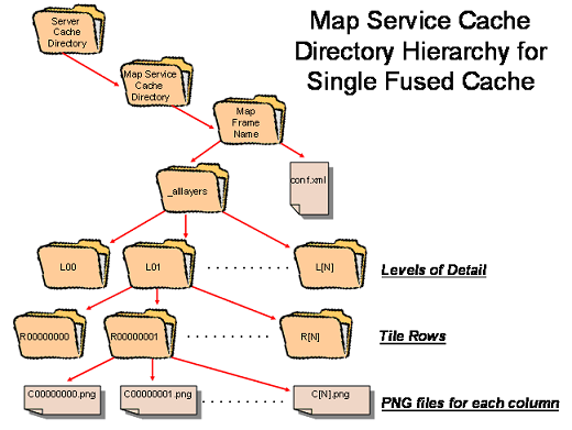
   A single-fused cache is organized into a 3-dimensional grid corresponding to a directory hierarchy that has upper level directories (labeled as

levels of detail) that contain directories (labeled with row numbers) containing all the image tiles (labeled with column numbers) for a given row.

Multi-layer caches have an additional level of hierarchy at the top consisting of directories (labeled with layer names) that contain the level-of-

detail directories. The tiles are all the same size and have pixel dimensions that are a user-selectable 128, 512, or 1024 pixels in size. Tiles are 3
 
band (8 bit each) PNG-24 images with the background color set to transparent by default. If no background color is set in the map document

the background color will default to 253,253,253. This behavior can be changed in ArcMap.